Historical weather data for wind and solar resources
Timeline
2013-2023Sector
Renewable energy: wind and solarScope
Weather data for wind and solar resourcesBACKGROUND
Developing of strategies inherent to Dynamical Downscaling with the aim of offering a wide range of weather products that help carry out a climate characterisation of wind and solar sites.
From the so called "wind and solar atlas", normally with horizontal resolutions from 3 to 1 km, to tabular data and long-time series generated using LES (Large Eddy Simulation) models, SOLUTE's weather and numeric modelling team works to reduce the uncertainty that is associated with this data.
Our products can be used for very specific purposes such as forecasting extreme wind systems, specific data for wind and solar resource projects, average wind turbine icing conditions, etc.
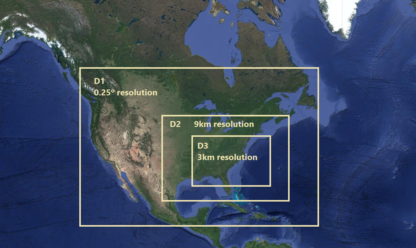
Based on reanalysis data from global models (ERA5, MERRA2, CFSR) and thanks to the use and mass execution of the WRF (Weather Research and forecasting) model, after progressive calculation and validation cycles, we are able to reconstruct historical series of the different weather variables. Changing the spatial resolution and approximations made in each configuration of the WRF model, different products are devised, which assess and strictly guide the different phases of a wind resource project. This way we are able to offer quality historical weather information to customers through the use of different models, algorithms and tools.

RESULTS
With this set of products, SOLUTE become a supplier of meso and micro-scaling data, taking advantage of our meteorological modelling capabilities and our good standing as a wind energy consultant. To achieve this goal, we had to configure a scalable and flexible calculation system, thanks to commercial agreements with suppliers on the cloud.
OTHERS USES AND APPLICATIONS
Weather characterisation processes requires having extensive historical databases of the local weather conditions (average temperature, rainfall, etc.). On many occasions we are not able to access observations from automatic weather stations or these are not sufficiently representative at the local level. Long-range mesoscale series are the natural alternative in these situations. SOLUTE, through its meso and micro scale products and the accessibility achieved with the new API REST, guarantees it can provide a reliable source of local weather data to its customers. Other sectors such as the agricultural sector can also benefit from this data.
FOCUS
The potential customers of this capability are wind project engineering consulting firms, developers and producers or other companies that have completed different steps during the early phases of a wind/solar park project.
For nearly a decade now, SOLUTE has traditionally operated as a technical consulting firm for these types of companies. This data inventory completes our wind surveying services.

METHODOLOGY
The tools that are used are the Weather Research and Forecasting (WRF) limited area numeric model, the Python programming language and georeferencing maps QGIS and ARCGIS. The team has specific technical qualifications and know-how in the use of numeric models such as WRF, mesoscale modelling, handling of global models in .grib2 format, in-depth knowledge of Python for data processing and in prediction validation techniques.
Weather modelling requires a complete know-how of different areas, from weather dynamics to the configuration of LES (Large Eddy Simulation) models as well as synoptic meteorology, mesoscale dynamics, numeric time modelling, validation of prediction models, uncertainty of the numeric models, Python or Meteorology for wind parks.
In terms of the technical requirements, storage is required, for downloading re-assessment data (ERA5, MERRA2 and CFSR) as well as for our own simulations. The amount of computation required for configuring these services, the sensitivity tests calculation, the generation of data and their systematic validation is enormous.
The final output is summarised in the following products/services developed by SOLUTE:
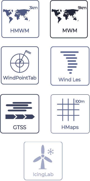
1. MWM (Mesoscale World Maps): maps of the average wind speed conditions, direction, temperature, humidity and density at different altitudes (10, 20, 30, 40, 50, 80, 100 and 120) in a grid with 9 km of resolution obtained from mesoscale models.
2. HMWM (High Resolution Mesoscale World Map): this is a service to provide mesoscale data with 3 km of resolution for the initial phases of the wind resource assessment, available for on land as well as off shore.
3. WindPointTab: this is a product that contains historical weather information, obtained through high resolution models for each site in tabular format. There are two versions of this product based on the method that is used in each case.
4. GTSS (Global Time Series): SOLUTE offers this product in time series format, which is part of the 3 km WRF modelling and includes the wind speed and direction, temperature and pressure; the time zone is selectable so that it matches the time stamp of the measurements; the atmospheric stability variables (RMOL and Richardson Number) and the base data can be selected from ERA5, MERRA2 and CFSR.
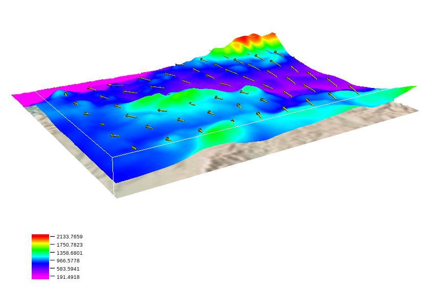
5. HMaps: result of the optimisation of a WRF-1km model of 20 years and the subsequent reduction of the data to a mesh of 100 metres containing key meteorological (and non-meteorological) variables for assessing any wind resource.
6. IcingLab: contains essential information about the historical conditions of ice formation on wind turbines for a specific region. Icing conditions may be caused by different factors such as freezing rain (liquid hydrometeor that freezes when it comes in contact with a solid surface) or icing conditions, temperatures below 0º with high humidity.
7. Wind-LES: SOLUTE's atmospheric modelling team has implemented different strategies for developing specific LES (Large Eddy Simulations) models for specified locations based on the implementation of free WRF software. The data obtained thanks to this modelling is especially useful during advanced phases of a wind resource project. In different parts of these types of projects, it is essential to have LES data, where the quality of this data intervenes in different processes: MCP (Measure Correlate Predict) methodologies to fill voids in the measured data series, for projects in which there is no measured data as well as for long term corrections of the calculated raw energy.
Software
Backend
Backend development is the part of an application that manages the information provided by the user and which controls the processes that manipulate this information to obtain the required results.
Solar
Design of solar installation for self-consumption
Estimation of energy production in a self-consumption photovoltaic plant through a correct definition and sizing of the installed equipment to reduce uncertainty and maximise savings.